

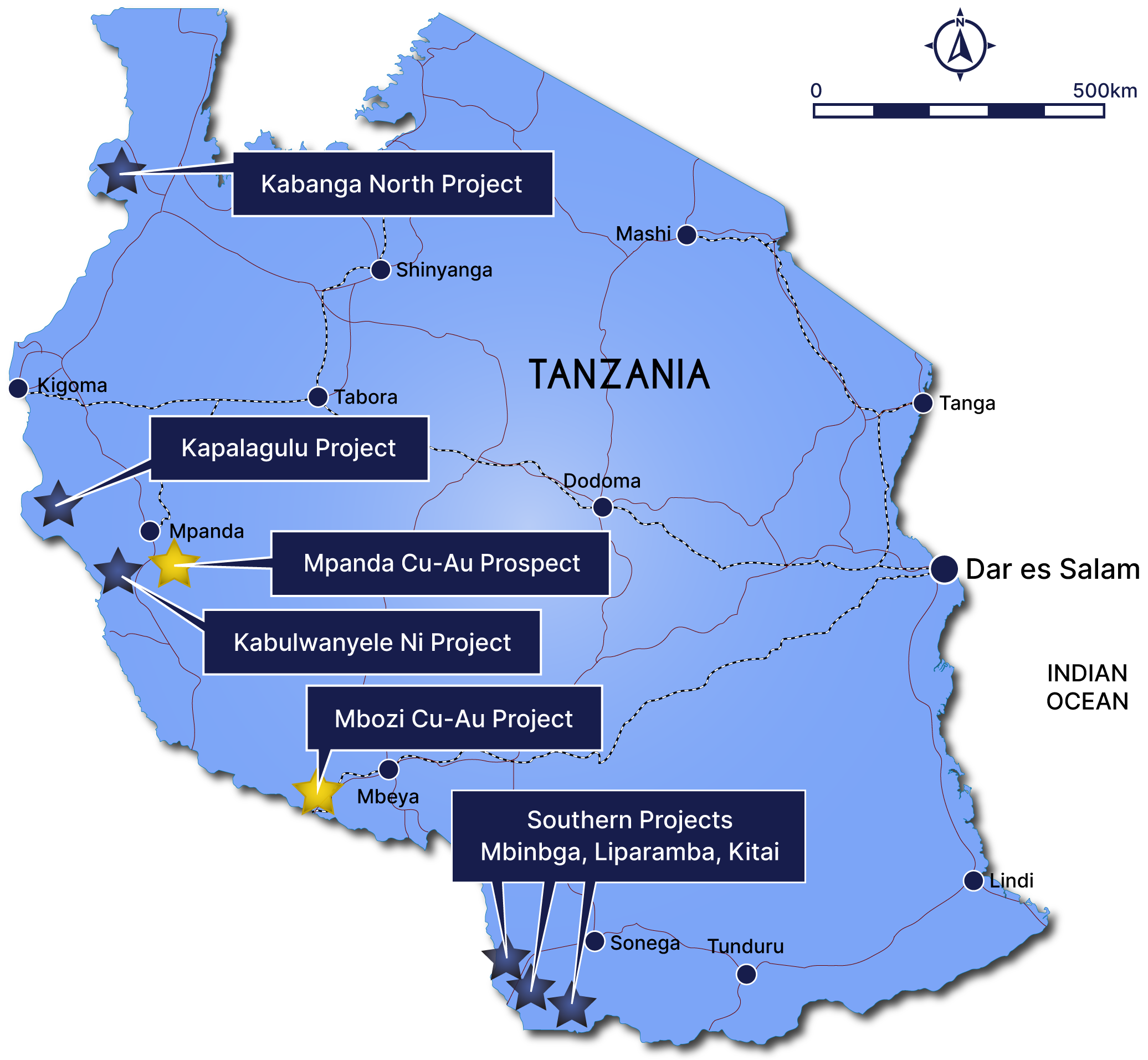
TANZANIAN PROJECTS
Tanzanian Projects Overview
Resource Mining has commenced exploration on prospective targets previously explored by BHP/Albidon.
RMC recently acquired two copper-gold projects, Mpanda and Mbozi, located within some of the most prospective ground in the Ubendian Orogenic Belt.
The Southern Projects include Liparamba, Kitai and Mbinga nickel projects, which were previously explored by BHP/Albidon and Jacana Resources.
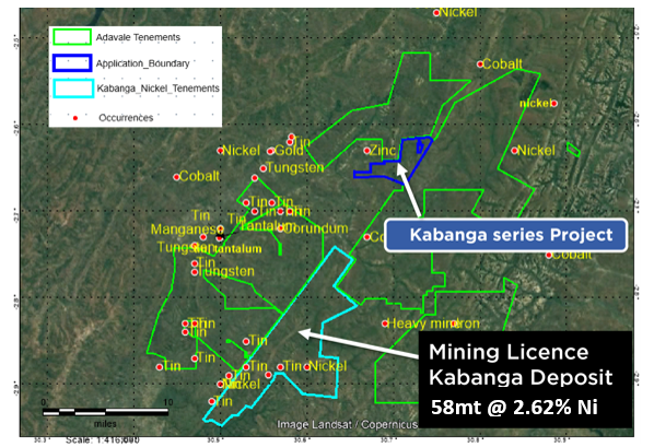
Kabanga North is along strike from the Kabanga Nickel project, which has an estimated mineral resource of 58mt @ 2.62% Ni, or nickel equivalent grade of 3.14% (including cobalt and copper).
32km mapped mafic/ultramafic sequence with historical reports noting nickel, PGE and copper anomalism.
The Kabulanywele Nickel Project (KNP) licences cover an underexplored area where reconnaissance exploration conducted last century identified nickel and cobalt laterite mineralization.
Mpanda and Mbozi
RMC recently acquired two copper-gold projects, Mpanda and Mbozi, located within some of the most prospective ground in the Ubendian Orogenic Belt, a significant resource area in western Tanzania.
The Mpanda Copper-Gold project is considered highly prospective given its geological setting within the Ubendian Orogenic Belt. Copper has been produced from the Mpanda mineral field for close to a century and continues today with the development of the Katavi Mine.
In addition to historical production and historical exploration results, new soil sample and rock chip sample results and surface mapping at Mpanda demonstrate high tenor assays which suggest high prospectivity for copper.
The Mbozi Copper-Gold Project is prospective for copper and was initially explored by BHP. It sits withing a prospective setting within the geological setting of the Ubendian Orogenic Belt.
Mbozi is aligned with a number of major resources in the Lupa Goldfield which contain both Gold and Copper. The significant high-grade Luez Hill Copper Resource, as well as a significant number of anomalous copper results yet to be followed up, all align with the shear zone that traverses the project tenements.
High tenor copper soil anomalies have also recently been located in southern tenements which RMC will follow up with a view to planning a drilling program.
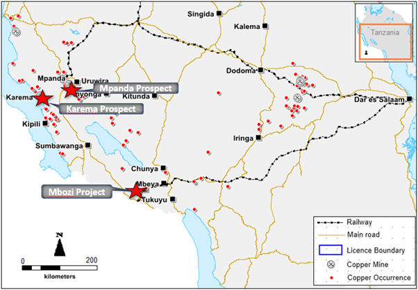
Figure 1: Location of the Mpanda and Mbozi Projects
Southern Projects
The southern projects comprise the Liparamba, Kitai and Mbinga Nickel Projects. These were previously explored by BHP/Albidon and Jacana Resources. Work completed by BHP included, airbone geophysics and stream sediment sampling. BHP generated a total of 19 EM targets and 6 geochemical anomalies over Liparamba and Mbinga. 24 diamond holes were planned to test the targets, but never drilled.
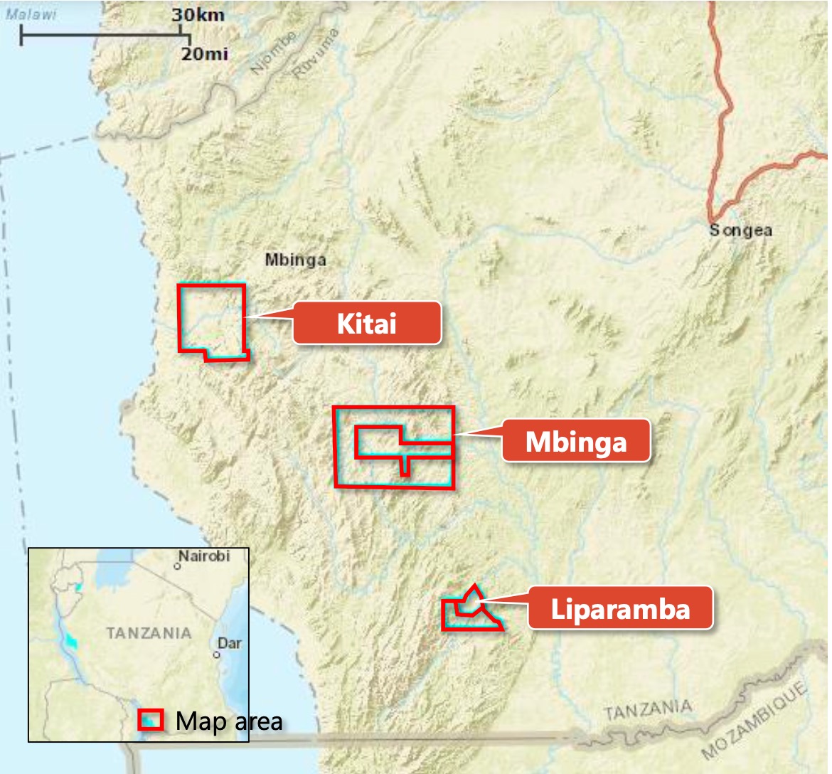
Figure 1: Location of the Southern projects: Liparamba, Kitai and Mbinga
Liparamba Project
A geophysical survey by Resource Mining confirmed BHP’s targets at Liparamba and identified new ones. A Reverse Circulation (RC) drilling program conducted by RMC intersected disseminated sulphides. Subsequently, nine 150-200m deep DD holes were drilled along the southern corridor of the Liparamba Nickel Project.
The DD program concentrated upon the coincidental anomalies identified in the Audio-frequency Magnetotellurics (AMT) and Airborne Electromagnetic (AEM) data, as well as recent geological field surveys and older soil surveys.
Anomalous Ni-Cu values were detected within a number of the drill holes from the diamond drill program at Liparamba, with Ni-Cu sulphide mineralization occurring at 133-135m within LPDD009 (0.35-0.40%Ni and 0.20-0.23%Cu).
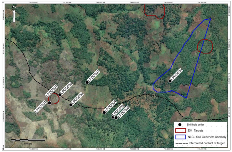
Figure 1: Location Map of Diamond Drill holes, Liparamba Ni Project
Kitai Project
The Kitai Project is host to a mapped ultramafic where a coincident zone of elevated conductivity is illustrated on the figure to the left.
This bodes incredibly well with regards to nickel prospectivity.
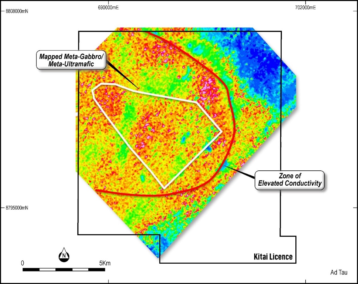
Figure 1: Kita Tenement with mapped ultramafic and coincident elevated conductivity.
Mbinga Project
The Mbinga Project is host to a low magnetics anomaly which could indicate the presence of an ultramafic intrusion. Whilst the target is conceptual, the bedrock lithology mapped in the area, coupled with geophysical anomalism, points towards the presence of a significant mafic/ultramafic unit present.
An auger sampling program was conducted at the Mbinga Project across a large Electro Magnetic (EM) target defined by BHP/Albidon. Initial results have proven very encouraging with the presence of anomalous Ni and Cu over the EM target and defined plate within the eastern region of the mafic inlier.
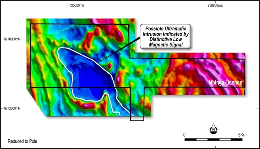
Figure 1: Mbinga Tenement with mapped ultramafic and coincident elevated conductivity
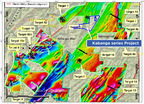
Kabanga North Nickel Project
Located within the same stratigraphy just 30 km along strike from the Kabanga Nickel project, which has an estimated mineral resource of 58mt @ 2.62% Ni, or nickel equivalent grade of 3.14% (including cobalt and copper).1
The Kabanga North Nickel Project is a single tenement of 22.54 km2. Host rocks display characteristic of the Kabanga Nickel project deposit, with mafic/ultramafic, micaceous phyllites and banded semi-pelites within the project area.
1 Refer to https://www.glencore.com/dam/jcr:7441d06f-2981-4f40-bd3b-93e4b074e921/GLEN-2014-Resources-Reserves-Report.pdf. The Mineral Resource Estimate is broken down into the following classifications – 13.8mT @ 2.49% Ni Measured, 23.4mT @ 2.72% Ni%
Kapalagulu Nickel (Copper+PGEs) Project
The Kapalagulu Project is comprised of 8 exploration tenements covering an area of 840 square kilometres.
The tenements are located 86 km straight distance North – West of Mpanda town and 1,149km from Dar es Salaam
Tenements share border and in similar strike with previously ASX.IMX owned Kapalagulu Nickel deposit with 113.1Mt@0.82% Ni.
Strategic holding targeting major NW-SE trending Ni-Cu Co mineralization. Two permits fall within the area of high gold occurrences.
Previous explorers soil Geochemical sampling, geophysics programs identified several exploration targets within the tenements.
Previous soil Geochem and EM anomalies coinciding making several walk up drilling targets
Large area of the tenements remain un explored and previous explorers geophysics targets not followed up.
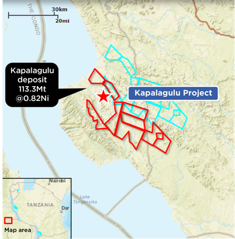
Figure 1: Tenement map for the Kapalagulu project
Kabulwanyele Nickel Project
The Kabulanywele Nickel Project (KNP) comprises two granted Prospecting Licences, PL/11534/2021 and PL/11535/2021, covering approximately 20.52 km in total, with one prospecting licence application covering approximately 0.27 km2 adjacent to the granted licence areas.
The Project is located in the Mpanda District of Tanzania, approximately 35km from the eastern shore of Lake Tanganyika, with the area forming part of the western limb of the East African Rift systems.
Kabulwanyele is a lateritic occurrence overlying a mafic-ultramafic layered intrusion. The nature of the exploration to date confirms the potential for both lateritic nickel zones as well as an underlying nickel-enriched source within the mafic-ultramafic inlier.
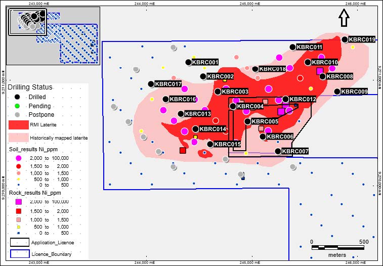
Figure 1: Map of Kabulwanyele project showing the completed drilling program over previous mapping and sampling